Share your favorites on Show & Tell

Robinson’s map of Sydney, Australia (1922)

In Paper > Maps > Show & Tell.
BigMapBlog's items4 of 4Koch’s Seattle, Washington Birdseye Map (1891)Idrisi’s “Tabula Rogeriana” World Map (1154)
1
Love it
0
Like it

aghcollectaghcollect loves this.
Add to collection

    Please create an account, or Log in here

    If you don't have an account, create one here.


    Create a Show & TellReport as inappropriate


    Posted 14 years ago

    BigMapBlog
    (4 items)

    (Entirely free) full-resolution file download available on the Big Map Blog: [6,499px × 9,126px]
    www.bigmapblog.com/2011/robinsons-aeroplane-map-of-sydney-1922/

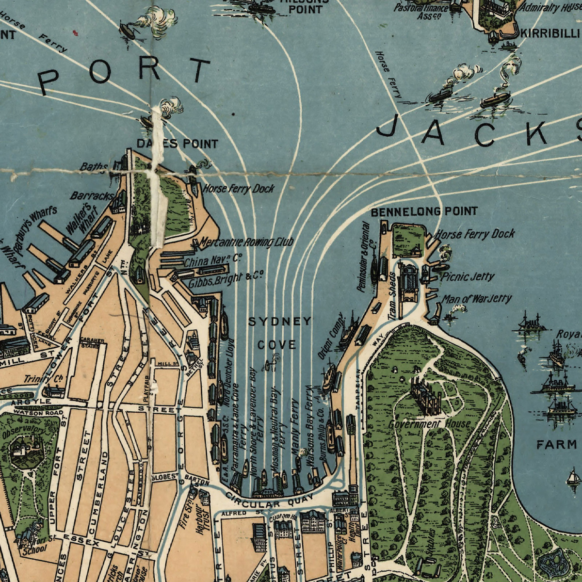
    Fun-looking and quite expertly-rendered overhead map of Australia's most populous city: Sydney, NSW [gmap] in 1922.

    Now I've noticed a pattern here in the U.S. that may or may not hold true in all cases: City-wide maps depicting a bustling, ebullient maritime or rail trade (such as this one) are often commissioned by towns in their early "salad days", right on the cusp of a real or imagined population or industry boom.

    I imagine it goes something like this (if you'll excuse my ad hoc psychoanalytics) -- you've got a city, and it's on the cusp of greatness... everything seems like it's just about to pop off. Seems like it just needs some more population and it'll snowball from there. Makes sense that that's when you spring for the map/public works project/exposition that shows the world your can-do spirit.

    (Entirely free) full-resolution file download available on the Big Map Blog: [6,499px × 9,126px]
    www.bigmapblog.com/2011/robinsons-aeroplane-map-of-sydney-1922/

    logo
    Maps
    See all
    Antique 18thC Engraved Colored Southern America Virginia Coastline Atlas Map
    Antique 18thC Engraved Colored Sout...
    $66
    RUSSIA & SCANDINAVIA 1623 HENRICUS HONDIUS UNUSUAL ANTIQUE COPPER ENGRAVED MAP
    RUSSIA & SCANDINAVIA 1623 HENRICUS ...
    $96
    EUROPEAN CONTINENT 1740 MATTHÄUS SEUTTER UNUSUAL ANTIQUE COPPER ENGRAVED MAP
    EUROPEAN CONTINENT 1740 MATTHÄUS S...
    $145
    GREECE 1540 PTOLEMY & SEBASTIAN MÜNSTER UNUSUAL ANTIQUE ORIGINAL lWOODCUT MAP
    GREECE 1540 PTOLEMY & SEBASTIAN MÜ...
    $26
    logo
    Antique 18thC Engraved Colored Southern America Virginia Coastline Atlas Map
    Antique 18thC Engraved Colored Sout...
    $66
    See all

    Want to post a comment?

    Create an account or login in order to post a comment.