Share your favorites on Show & Tell

NY,NJ and part of PA Map

In Paper > Maps > Show & Tell.
Maps137 of 169Ruth Taylor Texas State map 1935 comic cartographWorld Map
1
Love it
0
Like it

SEAN68SEAN68 loves this.
Add to collection

    Please create an account, or Log in here

    If you don't have an account, create one here.


    Create a Show & TellReport as inappropriate


    Posted 14 years ago

    Flash1fitn…
    (36 items)

    I'm not really sure, I think this is a repo.
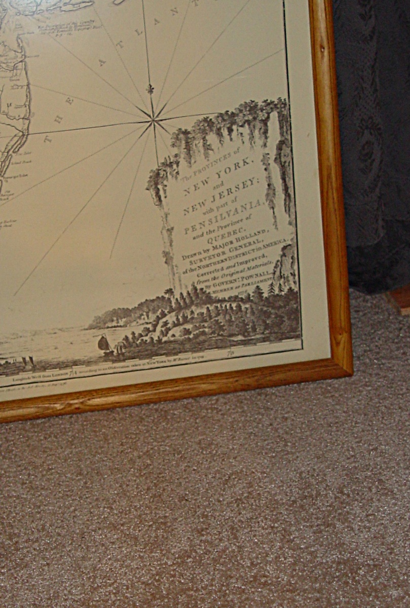
    Bottom of map says:
    "Printed by Headly Brothers Ltd, Ashford Kent"
    on the map it says:
    "Londen. Printed for Rob Sayer & John Bennett,
    No58, in Fleet Street, as the Actdirects Aug 17, looks like 1776"

    Bottom right of map says:
    The Providence of New York & New Jersey with part of Pensilvania and the providence of Quebec.
    Drawn by Major Holland, Surveyor General
    of the Northern District in America.
    Corrected and Improved. from the Original Materials.
    By Govern:Pownall
    Member of Parliment
    1776

    logo
    Maps
    See all
    POLAND & LITHUANIA 1729 HOMANN UNUSUAL ANTIQUE ORIGINAL COPPER ENGRAVED MAP
    POLAND & LITHUANIA 1729 HOMANN UNUS...
    $238
    GIBRALTAR & ANDALUSIA SPAIN 1730 SEUTTER UNUSUAL ANTIQUE COPPER ENGRAVED MAP
    GIBRALTAR & ANDALUSIA SPAIN 1730 SE...
    $117
    PHILIPPINES INDONESIA SOUTHEASTERN ASIA EAST INDIES 1702 SCHERER ANTIQUE MAP
    PHILIPPINES INDONESIA SOUTHEASTERN ...
    $38
    POLAND & LITHUANIA 1776 ROBERT DE VAUGONDY UNUSUAL ANTIQUE COPPER ENGRAVED MAP
    POLAND & LITHUANIA 1776 ROBERT DE V...
    $190
    logo
    POLAND & LITHUANIA 1729 HOMANN UNUSUAL ANTIQUE ORIGINAL COPPER ENGRAVED MAP
    POLAND & LITHUANIA 1729 HOMANN UNUS...
    $238
    See all

    Comments

    1. Flash1fitness Flash1fitness, 14 years ago
      Wow that is interesting. anything is possible!

    Want to post a comment?

    Create an account or login in order to post a comment.