Share your favorites on Show & Tell

Map of principal plantations of South Carolina Coast 1937

In Paper > Maps > Show & Tell.
Maps62 of 169Unknown map I need some help finding out about it.400  hundred year old map by  braun and hogenberg
4
Love it
0
Like it

iggyiggy loves this.
auraaura loves this.
fortapachefortapache loves this.
blunderbuss2blunderbuss2 loves this.
See 2 more
Add to collection

    Please create an account, or Log in here

    If you don't have an account, create one here.


    Create a Show & TellReport as inappropriate


    Posted 10 years ago

    Atlmom
    (17 items)

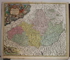
    Found this map in basement of building. Dated 1937. Map of plantations of South Carolina with names. Elliman & Mullally plantations, shooting properties & town homes.
    C.T. Lowndes & Co. Est 1850. Has some water damage but wonderful find. Some names of towns aren't spelled same as they are now.

    logo
    Maps
    See all
    NORTH AMERICA TEXAS AS REPUBLIC 1844 WYLD UNUSUAL ANTIQUE COPPER ENGRAVED MAP
    NORTH AMERICA TEXAS AS REPUBLIC 184...
    $102
    MORAVIA CZECH REPUBLIC & POLAND 1720 HOMANN UNUSUAL ANTIQUE COPPER ENGRAVED MAP
    MORAVIA CZECH REPUBLIC & POLAND 172...
    $67
    MORAVIA CZECH REPUBLIC 1720 HOMANN UNUSUAL ANTIQUE ORIGINAL COPPER ENGRAVED MAP
    MORAVIA CZECH REPUBLIC 1720 HOMANN ...
    $22
    UPPER CANADA 1846 WYLD OVERSIZE UNUSUAL ANTIQUE ORIGINAL COPPER ENGRAVED MAP
    UPPER CANADA 1846 WYLD OVERSIZE UNU...
    $128
    logo
    NORTH AMERICA TEXAS AS REPUBLIC 1844 WYLD UNUSUAL ANTIQUE COPPER ENGRAVED MAP
    NORTH AMERICA TEXAS AS REPUBLIC 184...
    $102
    See all

    Want to post a comment?

    Create an account or login in order to post a comment.