Share your favorites on Show & Tell

Map from World War II

In Paper > Maps > Show & Tell and Military and Wartime > World War Two > Show & Tell.
Maps35 of 167Phelps’s National Map of The United State Dated 1852 Another 1936 , First Contact
4
Love it
0
Like it

hunterqleehunterqlee loves this.
blunderbuss2blunderbuss2 loves this.
yougottahavestuffyougottahavestuff loves this.
fortapachefortapache loves this.
See 2 more
Add to collection

    Please create an account, or Log in here

    If you don't have an account, create one here.


    Create a Show & TellReport as inappropriate


    Posted 5 years ago

    Carlie
    (21 items)

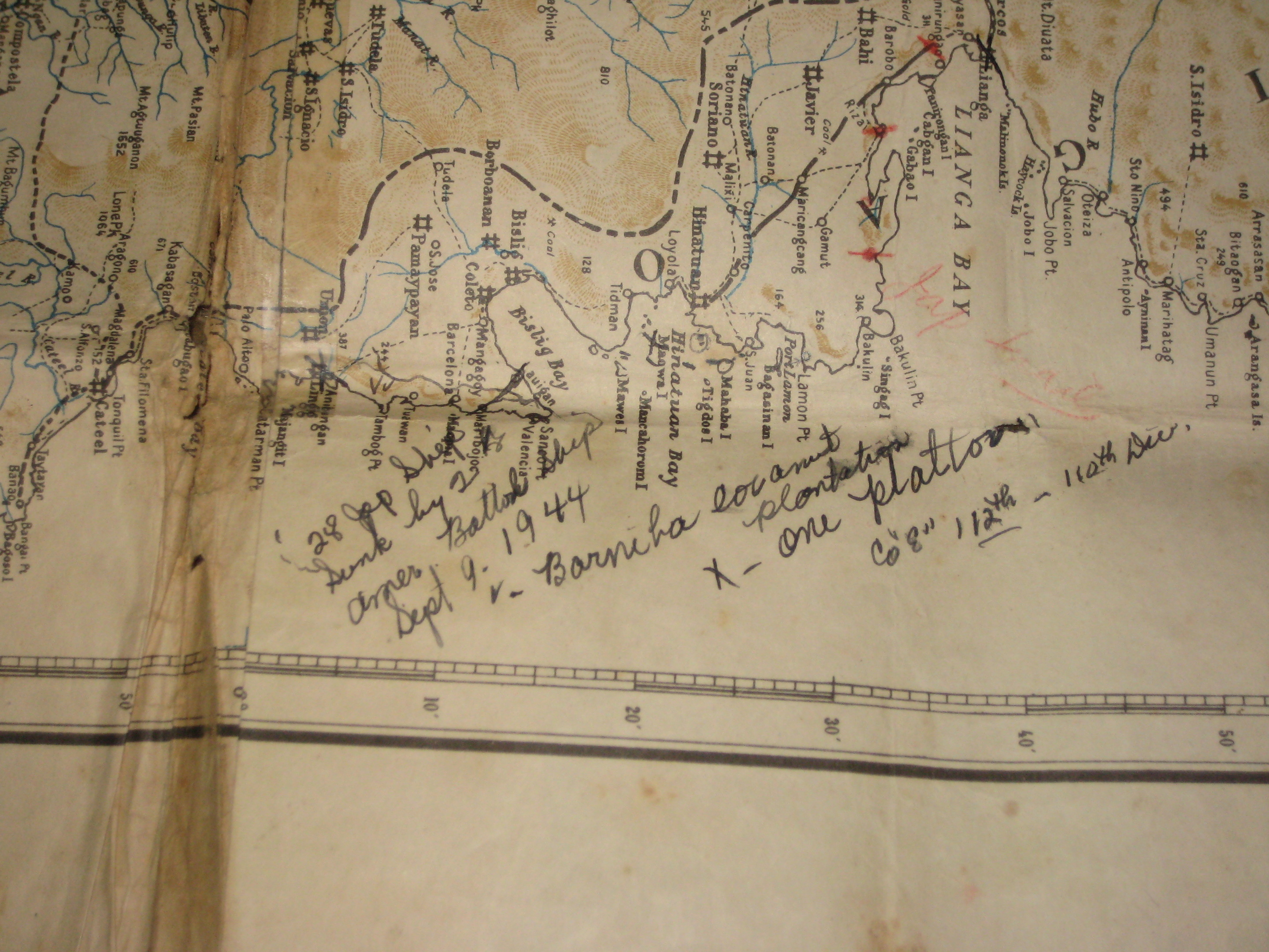
    My daddy brought this map back from the Philippines after W.W.II. Written on the back is that it was "Jap Owned." There are Japanese characters all over the back and notes on the map itself concerning ships that were attacked, spots where fellow soldiers were killed, etc. Daddy was a medic, so he probably noted the exact spot on this map. I have it folded, wrapped in plastic wrap and in a trunk. I have no idea what the characters mean.

    logo
    Maps
    See all
    c1542 MUNSTER HISPANIA III NOVA TABULA HAND COLOURED ENGRAVED MAP SPAIN PORTUGAL
    c1542 MUNSTER HISPANIA III NOVA TAB...
    $127
    WORLD CALIFORNIA AS AN ISLAND 1720 CHATELAIN ANTIQUE COPPER ENGRAVED WORLD MAP
    WORLD CALIFORNIA AS AN ISLAND 1720 ...
    $63
    NORTH AMERICA 1748 GEORGE LOUIS LE ROUGE UNUSUAL ANTIQUE COPPER ENGRAVED MAP
    NORTH AMERICA 1748 GEORGE LOUIS LE ...
    $32
    SILESIA POLAND 1612 ORTELIUS UNUSUAL ANTIQUE COPPER ENGRAVED MAP SPAHISH EDITION
    SILESIA POLAND 1612 ORTELIUS UNUSUA...
    $21
    logo
    c1542 MUNSTER HISPANIA III NOVA TABULA HAND COLOURED ENGRAVED MAP SPAIN PORTUGAL
    c1542 MUNSTER HISPANIA III NOVA TAB...
    $127
    See all

    Comments

    1. Carlie Carlie, 5 years ago
      Thanks for the love guys!!

    Want to post a comment?

    Create an account or login in order to post a comment.